
Autodesk has just released Civil 3D 2020.1 Update for download. You can download and install this update via your Autodesk Account or from the Autodesk Desktop App. Full release notes can be viewd at THIS LINK.
Bug Fixes
This update contains several bug fixes and product enhancements. Bug fixes include major fixes to the following items:
- Fixed an issue in which superelevation of subassemblies created from the Subassembly Composer was not incorporated into a corridor.
- Fixed an issue in which data shortcut references would not synchronize correctly.
- Fixed an issue in which a data shortcut could be created from an unsaved drawing, which would result in a data shortcut without a source object.
- Fixed an issue in which the elevation of a feature line was set to zero when using the AUDIT command.
- Fixed an issue in which a curb and gutter component would be in the wrong orientation when brought into Civil 3D from InfraWorks
- Fixed an issue in which a pipe centerline that was referenced into a drawing using an xref was displayed using the color of the xref layer..
- Fixed an issue in which the point data in a .csv file parsed incorrectly during the point import process when the data contained user defined properties.
- Fixed an issue in which survey figure data imported incompletely.
- Fixed an issue in which you could not select a network path as the working folder for a survey database.
A complete list of bug fixes can be found here: C3D 2020.1 Release Note Bug Fixes
Autodesk Connector for ArcGIS Online
A major component of this update is the release of the Autodesk Conenctor for ArcGIS for Civil 3D allowing you to directly connect to Esri’s ArcGIS Online system and add data layers as Civil 3D Features in your design.
With the Connector for ArcGIS you can bring ArcGIS data layers that contains points, lines, polygons, feature lines, gravity pipes, parcels, or structures into your Civil 3D drawings. When you bring in each layer, you can specify what type of Civil 3D object to create. This helps you more efficiently generate the existing conditions for your specific area of interest.
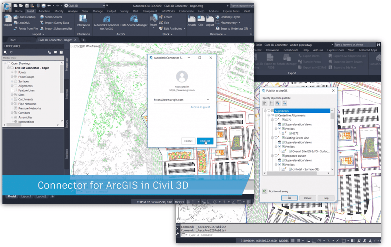
You can now bring ArcGIS Online data directly into a Civil 3D drawing and make changes to that data in Civil 3D! The Data Source Manager allows you to save back any updates to the data layer back into ArcGIS. Because the Connector for ArcGIS maintains a live link to ArcGIS Online, this helps ensure that consistency is maintained between what is being designed and what is in the GIS.
You can now also directly publish Civil 3D objects into ArcGIS including alignments, feature lines, parcels, pipe networks and points. The Export to FGDB command enables you to export Civil 3D objects directly to a File Geodatabase that can be used in ArcGIS or other applications.
For more information, please contact me at [email protected] or email us at [email protected]
Leave A Comment