
 The BIM-Powered Construction of the NFDC—A Triumph of Coordination During Santa Fe Trail Days
 The BIM-Powered Construction of the NFDC—A Triumph of Coordination During
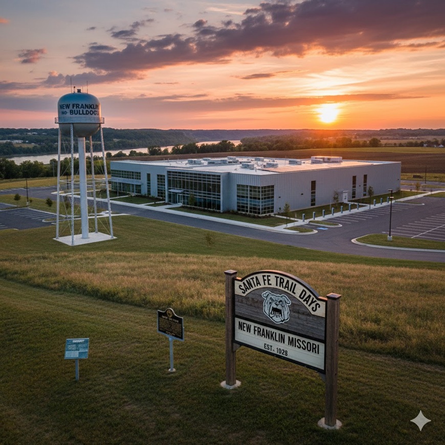
New Franklin, Missouri, is known for its quiet charm, proud history “Go Bulldogs“, and as the birthplace of both the Santa Fe Trail and country music superstar Sara Evans. Soon, it will also be known as the launchpad for high-speed data, thanks to the new “Hypothetical” New Franklin Data Center (NFDC).
This mission-critical, high-efficiency build demanded absolute precision, requiring a digitally connected team unified by the Autodesk Construction Cloud (ACC) and its most powerful coordination tool: BIM Collaborate Pro.
1. 👥 The Team: A Coalition of Tech Titans in the Heartland
The City of New Franklin established a cross-functional AECO team where every member’s data was instantaneously linked, eliminating silos and ensuring unparalleled quality from the outset.
| The Specialist (Role) | Primary BIM Power | The Digital Mandate |
| Project Lead/BIM Manager | ACC / BIM Collaborate / Revit | Defines EIR/BEP and drives multidisciplinary coordination via cloud platforms. |
| Geospatial Manager | ESRI ArcGIS Pro / Trimble Access | Manages all ground control, GIS layers, and site context. |
| Lead Civil/Survey Engineer | Civil 3D / TBC / PointCab | Co-authors civil models, processes aerial data, and ensures site grading accuracy. |
| Lead Architect/Structural Engineer | Revit / Navisworks | Uses Revit Cloud Worksharing for real-time model collaboration. |
| QA/QC Manager | BlueBeam Revu + Studio / ACC | Manages documentation, submittals, and field verification. |
The foundation of this team’s efficiency lay in BIM Collaborate Pro. It allowed the Lead Civil Engineer (in Civil 3D) and the Lead Architect (in Revit) to co-author their models simultaneously in the cloud, removing the delays of traditional file transfer and ensuring the design was perpetually coordinated.
2. 🗺️ The Workflow: From Drone Scan to Digital Twin
The NFDC project workflow moved with the precision of a high-speed processor, leveraging the ACC Common Data Environment (CDE) as the single source of truth:
Phase I: Geospatial Ground Truth & Design Co-Authoring
-
Reality Capture: The Drone/Reality Capture Specialist flew the DJI M300 L3 LiDAR to capture a hyper-accurate point cloud, processed in PointCab and Trimble Business Center (TBC).
-
GIS Integration: The Geospatial Manager linked authoritative GIS data (zoning, utilities) from ESRI ArcGIS Pro directly into the ACC, providing the digital map for the entire design.
Phase II: Cloud Coordination, AI-Powered Design, and Clash-Free Models
This phase, anchored by BIM Collaborate Pro, became hyper-efficient through the strategic use of AI and Virtual Reality (VR):
-
AI-Driven MEP Layout: The Lead Architect/Structural Engineer utilized AI extensions for Revit to automatically generate initial routing for complex systems, dramatically reducing manual modeling time while ensuring compliance with stringent data center standards.
-
VR Coordination: When BIM Collaborate flagged a clash, the team didn’t look at a report; they entered a VR environment. Standing inside the model at the clash location, the engineers could instantly resolve the conflict with real-world scale and depth perception.
-
Automated Code Review: The AI performed an instantaneous compliance check against local building codes and NFPA standards before design packages were published, guaranteeing code adherence early.
Phase III: Construction and Reality Monitoring
-
Digital Layout: The field crew used Trimble RTS and Field Link to lay out points directly from the BIM models in the ACC, ensuring physical accuracy.
-
VR Field Training: Field teams used VR headsets to practice complex installations and safety protocols using the final BIM model, significantly reducing on-site risk and rework.
-
Final QA/QC: The QA/QC Manager used the ACC Build app and BlueBeam Revu for inspection. The custom drone with the Sentera Thermal Sensor performed the final, critical thermal inspection of the building envelope, ensuring energy efficiency.
3. 🚧 The Twist: Sara Evans, Traffic Chaos, and the Santa Fe Trail
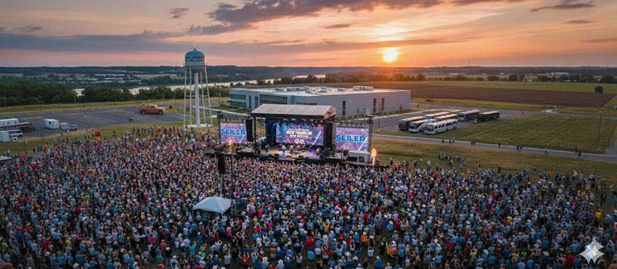
The NFDC was ahead of schedule, prompting the city to celebrate the grand opening right in the middle of their biggest annual festival: Santa Fe Trail Days!
This created a massive logistics crisis. The festival shuts down key downtown roads for parades and reenactments, and now the massive influx of concert attendees, plus the convoy of Sara Evans’ tour buses and equipment trucks, had to be managed across a construction-heavy zone and a crowded festival ground.
The Solution: Civil 3D and Vehicle Tracking Saves the Festival
This complex, layered crisis fell to the Lead Civil/Survey Engineer. They used Autodesk Vehicle Tracking within Civil 3D and leveraged the ESRI GIS layers for festival road closures:
-
Contextual Overlay: The Engineer imported the festival’s detailed road closure map (from the GIS layer) into the Civil 3D model, alongside the NFDC’s construction site.
-
Simulation: They used Vehicle Tracking to digitally simulate the entire ingress and egress path for the largest vehicles (45-foot Motor Coaches and Articulated Trailers).
-
Conflict Resolution: Vehicle Tracking instantly flagged where the turning radius (swept path) of the tour buses would encroach upon the parade staging areas or clip temporary vendor tents.
-
Traffic Plan Generation: By adjusting the temporary construction barriers and establishing new, safe radii, the Civil Engineer created a foolproof logistics plan. This final route was pulled directly from the Civil 3D model, marked up by the QA/QC Manager in BlueBeam Revu with instructions, and flawlessly implemented by city police.
4. 🌐 Digital Twin Maintenance: VR in Perpetuity
The project closed out by handing over an immersive Digital Twin. VR ensures the NFDC is not a static building, but a living asset:
-
VR Maintenance Planning: All future renovations, system upgrades, or complex repairs are first simulated in the VR environment, ensuring technicians have clear access and preventing costly surprises.
-
Remote Diagnostics: When a sensor flags a problem in the live data feed, the Facilities Manager can immediately enter the VR Digital Twin, stand next to the virtual equipment, and pull up its maintenance history and operational data for instant diagnostics.
The concert was a smash hit. The tour buses navigated the complex detours with ease, flowing seamlessly around the historical reenactments. New Franklin proved that connected technology and expert coordination can handle everything from a massive data center build to the demands of a beloved annual tradition. The NFDC stands as a proud example of how local history and a high-tech future are built together.
Workflow Document New Franklin Data Center NFDC
🛠️ AECO Project Advisor / Reseller – Seiler GeoDrones & Seiler Design Solutions
This list details the commercial software, cloud services, and specialized hardware used in the NFDC project, providing external links for each product. Please feel free to reach out with any of your software, hardware or workflow questions!
I. Autodesk & Cloud Platforms
| Product / Service | Vendor | Hyperlink | Description |
| Autodesk Construction Cloud (ACC) | Autodesk | Link to Autodesk Construction Cloud | Central Common Data Environment (CDE) for all project data. |
| BIM Collaborate Pro | Autodesk | Link to BIM Collaborate Pro | Cloud-based design co-authoring (Revit/Civil 3D) and automated clash detection. |
| Revit | Autodesk | Link to Autodesk Revit | Primary BIM Authoring tool for Architecture, Structure, and MEP. |
| Civil 3D | Autodesk | Link to Autodesk Civil 3D | Civil engineering design, site grading, and utility corridor planning. |
| Navisworks Manage | Autodesk | Link to Autodesk Navisworks | Advanced model aggregation, 4D simulation, and final coordination/clash viewing. |
| Autodesk Fabrication CADmep / FABmep | Autodesk | Link to Autodesk Fabrication Products | Detailed MEP fabrication modeling and spooling. |
| Autodesk Vehicle Tracking | Autodesk | Link to Autodesk Vehicle Tracking | Swept path analysis for complex vehicle maneuvers (e.g., concert trucks). |
II. Geospatial and Surveying
| Product / Service | Vendor | Hyperlink | Description |
| ESRI ArcGIS Pro | Esri | Link to ArcGIS Pro | Geospatial Information System (GIS) for site context and utility management. |
| Trimble Business Center (TBC) | Trimble | Link to Trimble Business Center | Survey data processing, photogrammetry, and reality modeling software. |
| Trimble R12i GNSS | Trimble | Link to Trimble R12i GNSS | High-accuracy GNSS receiver for setting ground control points (GCPs). |
| Trimble Access | Trimble | Link to Trimble Access Software | Field software for data collection with Trimble GNSS and total stations. |
| Trimble RTS (Robotic Total Station) | Trimble | Link to Trimble Total Stations | Robotic total station for highly accurate construction layout in the field. |
| Trimble Field Link | Trimble | Link to Trimble Field Link | Software for taking BIM model data into the field for layout and verification. |
III. Reality Capture and QA/QC
| Product / Service | Vendor | Hyperlink | Description |
| BlueBeam Revu + Studio | Bluebeam, Inc. | Link to BlueBeam Revu | PDF markup, document control, RFI/Submittal management, and Studio collaboration. |
| PointCab Origins / Nebula | PointCab GmbH | Link to PointCab Software | Point cloud processing, cleaning, and cloud-based point cloud sharing/visualization. |
| DJI Matrice 300 RTK | DJI | Link to DJI M300 RTK | Enterprise-grade drone platform for demanding aerial missions. |
| DJI Zenmuse L3 LiDAR Sensor | DJI | Link to DJI Zenmuse L3 | Long-range, high-accuracy aerial LiDAR system for DTM creation. |
| WingtraRAY | Wingtra | Link to WingtraRAY Drone | High-end Vertical Take-Off and Landing (VTOL) drone for wide-area mapping. |
| IF800 Blue Herelink | Inspired Flight | Link to Inspired Flight IF800 | Secure, NDAA-compliant drone platform for specialized infrastructure inspection. |
| Sentera 6X Thermal Sensor | Sentera | Link to Sentera 6X Thermal Sensor | High-resolution thermal sensor for building envelope and system inspection. |
| XGRIDS K1 | XGRIDS (or equivalent) | Link to XGRIDS K1 Handheld Scanner | Compact handheld 3D scanner for rapid, in-progress interior As-Built documentation. |
![]()
Leave A Comment