In this video, Seiler Design Solutions will introduce you to the GeoSLAM Zeb Locate system.
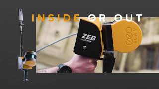
The GeoSLAM Zeb Locate utilizes the powerful Zeb Horizon scanner with its 100m range and 300,000 point per second scan capability, mounted to a backpack system along with a GNSS system to correlate your scan to real world locations.
The ZEB Locate is ideal for the rapid scanning of utility poles and power lines. Utilizing simple simple clip on clip off technology, the ZEB Locate is lightweight and comfortable to wear for large scanning jobs.
We’ll run through the operation of the system, process the data and utilize this data in Autodesk Civil 3D and Infraworks.
If you have any questions, please contact us at [email protected]. Follow our blog at https://seiler-ds.com/blog for more information.

You may also like

GeoSLAM PANO Project Setup
7:38
Would you like to know how to get your GeoSLAM PANO images into your ...
GeoSLAM RT and PANO: so easy a kid can do it!
Opening the GeoSLAM RT and PANO, assembly of the unit and setup for ...
GeoSLAM Winchester Mystery House
The Winchester Mystery House, an architectural wonder and historic ...
GeoSLAM ZEB Horizon Accessories - Seiler 2020
This video shows the range of accessories that can be used with the ...
Introducing the New GeoSLAM Zeb Horizon
Meet the latest member of the GeoSLAM family, the ZEB-HORIZON 3D ...
Introduction to the GeoSLAM ZEB Pano
1:36
Handheld mobile mapping. Capture Walk through a property with the ZEB ...
Introduction to the GeoSLAM ZEB Revo
2:51
The GeoSLAM ZEB-REVO is a indoor mapping solution that allows you to ...
Testing the DJI M600 Pro and GeoSLAM Zeb-Horizon at Seiler with data images
1:39
Seiler testing the new GeoSLAM Zeb-Horizon 3D mobile scanner with a ...