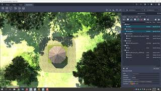
In this video, I demonstrate the Shared Reference Coordinate Extension from Autodesk to Reference a Civil 3D drawing coordinates back to my Revit model. The purpose behind the Shared Reference Coordinate extension is to allow the export and import of the models from Revit to match the coordinates of a Civil 3D drawing without having to manually move and rotate the objects relative to each other.

Unable to view 3rd party video sources like YouTube? Please watch using this alternative source.


You may also like

Adding Transparent Clearance Zones to Revit Families
4:48
Watch this video for a step by step account of how to add transparent ...
Autodesk Revit 2021.1 and Dynamo 2.6.1: Calculate Longest Distance
Learn how to use pre-made scripts in the latest Revit 2021.1 and ...
Autodesk Revit MEP Angle Settings How to Control Your Duct, Pipe, Conduit and Cable Tray!
Are you tired of your MEP design having so many different angles while ...
Civil 3D 2019.2 Profile Toolset and Transparent Command Ribbon Tab
4:37
Included with Civil 3D 2019.2 Update is a new Transparent Command ...
Civil 3D 2020.2 Design Collaboration in BIM360 Design
Design collaboration on civil infrastructure projects between two or ...
Civil 3D Surface Watershed Analysis
9:30
In this video, Seiler Design Solutions will show you how to display ...
Civil 3D Survey Basics - Wisconsin ACEC Civil 3D Workshop 2020
This is a recorded session that was presented at the Wisconsin ACEC ...
Civil 3D Tips and Tricks - Webinar Recording 10-13-2020
This video is a portion of our Webinar from October 13, 2020 on the ...
Page 1 of 4