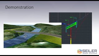
In this video, Seiler Design Solutions will show you how to display your Civil 3D surface as a Watershed Analysis style. The method of setting up your style will be described, along with some of the other options involved.
Once the Watersheds have been displayed, you will be shown how they can be used in conjunction with the Flow Path tool and the creation of Catchment areas that can be exported to Autodesk Storm and Sanitary Analysis for further use in drainage design.
Are you unable to view 3rd party video sources like YouTube? Please watch this alternative source.
If you have any further questions related to this video, please contact us.


Leave A Comment